To start, Bolivia is 1,098,581 square kilometers (about the size of Alaska, or twice the size of France). It is divided into 9 departments, which are subdivided into 112 provinces, and 327 municipalities. (A municipality is a bit like a county, with a main city and the surrounding rural areas and villages.) The population is about 10 million.
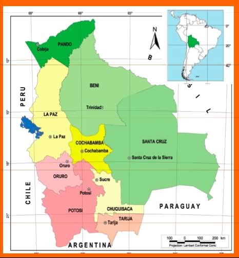
Map of Bolivia. Last time I was in La Paz, Beni, and Oruro. This time I visited La Paz, Cochabamba, and Santa Cruz.
The main thing to remember is that Bolivia is divided into the Altiplano (Highlands), Valleys, and Lowlands. Climate, agriculture, culture, and politics tend to differ along those lines. The Altiplano departments are: La Paz, Oruro, and Potosi. The Valley departments are: Cochabamba and Chuquisaca. The Lowland departments, which are often referred to as the Media Luna (Half Moon) are: Pando, Beni, Santa Cruz, and Tarija.
Bolivia is mostly a very poor country. 58% of the population lives under the poverty line in the last census and another 24% lives just above the poverty line. Of course, there is also some extreme wealth here in Bolivia, and plenty of inequality, often in the form of unequal distribution of land.
Bolivia's climate and ecosystems are all heavily impacted by the Andes. The range was created by the Nazca plate meeting the South American plate. If the Andes were a leg, Bolivia would be the knee.
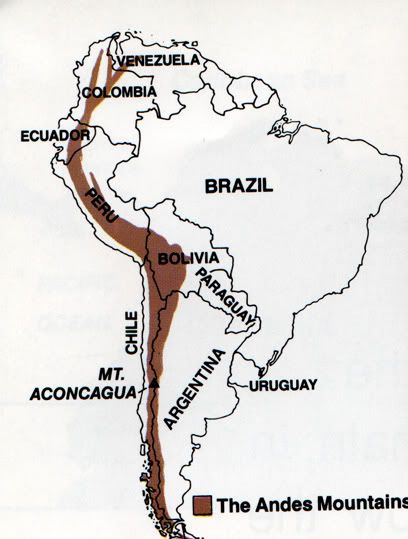
In Bolivia and Peru, two ranges of the Andes border a high plain known as the "Altiplano." About two thirds of the Altiplano fall in Bolivia and the rest is in Peru. The Cordillera Oriental is the range to the east, and the Cordillera Occidental is the range to the west. Bolivia's population has historically been concentrated in the Altiplano.
Here are a few maps that show Bolivia's temperatures, precipitation, and ecoregions (which I will elaborate on below):
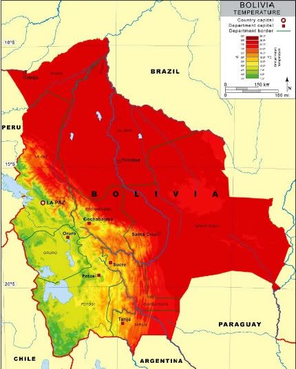
Temperatures
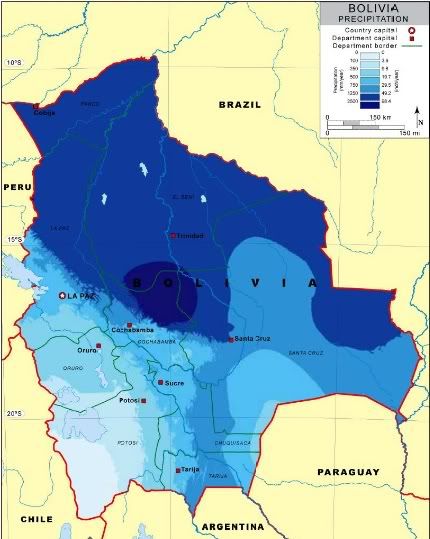
Precipitation
As you can see, precipitation is not consistent across each temperature zone. For example, the hot, tropical parts of Bolivia don't all get the same amount of rain - it ranges from very dry conditions in the Chaco (near Paraguay) to Amazon rainforest in the north.
The information below is likely TMI, but you can use it as a reference. Here are the Clif Notes:
- Altiplano: Cool weather with a long dry season. The area near Lake Titicaca is warmer and wetter than the area to the south of it.
- Valleys: Great weather. Like California, except with enough natural rainfall to grow food.
- Lowlands: HOT. Very wet in the north (the Amazon), with grasslands in much of Beni, a large tropical dry forest (Chiquitania) in Santa Cruz, Pantanal (like the Everglades) in the eastern part of Santa Cruz, and Chaco (very dry) in the south.
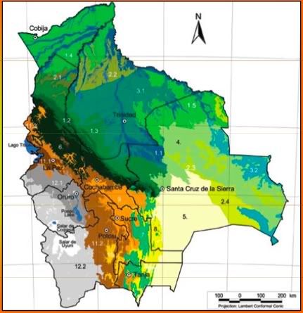
Key to the Eco-Regions:
1 Southwest Amazon Forests
1.1 Flooded Amazon Forests
1.2 Sub-Andean Amazon Forests
1.3 Pre-Andean Amazon Forests
1.4 Pando Amazon Forests
1.5 Beni and Santa Cruz Amazon Forests
2. Cerrado
2.1 Cerrado of La Paz
2.2 Cerrado of Beni
2.3 Cerrado of the Chiquitano Region
2.4 Cerrado of the Chaco Region
3. Flooded Savannahs
3.1 Moxos (Beni) Plains Flooded Savannas
3.2 Pantanal Flooded Savannas
4. Chiquitano Dry Forest
5. Gran Chaco
6. Yungas
7. Tucuman-Bolivian Forest
8. Montane Chaco
9. Inter-Andean Dry Forests
10. Pre-Puna
11. Northern Puna
11.1 Humid Puna
11.2 Semihumid Puna
11.3 High Andean Vegetation
12. Southern Puna
12.1 Dry Puna
12.2 Desert Puna and High Andean Vegetation
The northern part of the Altiplano in Bolivia receives warmth and moisture from Lake Titicaca, which is located in between Bolivia and Peru. This area ranges from 12,500-13,500 feet (3810 to 4100m) in altitude, and average temperatures are about 45-48F (7-9C). Annual rainfall averages 19-63 inches (500-1600mm) per year. Each year, they experience a long dry season (3-5 months but lately it's more due to climate change) in which it is dry. Although I am no fan of the World Wildlife Fund, I think they have a great description of humid puna. Animals here include the vicuña, guanaco, puma, the andean fox, and - my favorite - flamingos.
South of Lake Titicaca, the Altiplano is much colder and drier. These areas are classified as dry puna. We did not travel there this trip.
As the Andes gradually slope down toward the lowlands, there is an ecosystem known as Yungas. This area ranges from 3,300-13,800 ft (1000 to 4200m) in elevation, 45-75F (7-24C) in annual average temperatures, and 59-236 inches (1500 to 6000mm) of rainfall per year. They experience a much shorter dry season (up to 2 months) than the Altiplano and sometimes none at all.
Yungas is an extremely, extremely biodiverse area that is characterized by many epiphytic plants. Epiphytes are species that live together, neither symbiotically nor as parasites. Animal species here include parrots, toucans, capuchin monkeys, jaguars, tapirs, and spectacled bears. Major crops include coca, coffee, and many types of fruits and vegetables.
I will include more details in the future as I cover each place we visited on the trip. For now, let's turn the conversation to the climate crisis.
Bolivia is like the llama in the coalmine of climate change. The glaciers are already melting, and Bolivia's only ski resort is now just a nice place to hike. Much of the region's water comes from glacial melt, and so does much of the electricity (hydroelectric). Already, the water is less than it used to be. Over 40 million people live in the Andes, and many rely on hydroelectric power, which will be gone when the water runs out.
There will be much more on climate change in Bolivia later, so I will leave it at this for now.
No comments:
Post a Comment